EARTHQUAKE OVERVIEWS
Earthquakes of strength 4-6 may be considered as “medium”, 6-8 as “strong” and above 8 as “catastrophic” events.
Graphic presentations:
USGS Real-Time Earthquake Map Earthquakes during the last 30 days.
USGS Real-Time Earthquake Map Earthquakes during the last 7 days.
USGS Real-Time Earthquake Map Earthquakes during tha last 24 hours.
Real Time Feeds & Data Subpage of the page above..
Intellicast Click “Overlays” and choose “Earthquakes”.
IRIS. See its Earthquake Browser.
GEOFON Global Seismic Monitor.
emsc-cesem Interactive maps of Earthquakes (also shows minor quakes).
Center for Earthquake Research and Information
Recent Earthquakes & Active Volcanoes.
The Global Disaster Alert and Coordination System.
Survival Netzwerk (in German).
ZAMG Recent Earthquakes in central Europe.
ZAMG Recent Earthquakes in the world.
survival.4u Erdbebenmonitor (German).
Software
(freeware, require installation):
Earthquake 3D
(It
may happen
that the globe disappears from the screen. In that case, it is actually moved
away from the desktop area. If that occurs, find the file EQ3D.ini (possibly
Earthquake3D.ini) under C:\Windows and delete it. When Earthquake 3D is then
again started, this file is written anew.) There is also an “Extended Version”
for US$ 20.-.
Google Earth Real-time Earthquakes (requires Google-Earth Plug-in installed, unless you already have the full Google Earth).
Local reports:
Lamont-Dowherty Earth Observatory recent Earthquakes in the Northeastern U.S.
Yellowstone Seismic Activites (some claim that this page may be a bit censored).
Yellowstone Seismogram Thumbnails (shows the actual situation; click “Previous Day” stepwise for earlier overviews).
Reports in text and tables:
Earthquake Impact Database the world's most detailed logbook of damaging earthquakes.
GFZ Potsdam Earthquake Bulletin.
emsc-cesem Real Time Seismicity (also shows minor quakes).
NIEP.
Erdbeben-Earthquake-Terremoto (German).
Earthquake Diary (German and English).
Earthquake Prediction by Tiempe (German website in
English).
Erdbebenüberwachung (German) for seismologists
here (in English).
Pacific Tsunami Warning Center.
West Coast and Alaska Tsunami Warning
Center.
Volcano Discovery: What’s erupting?
Volcano El Hierro (Canary Islands), actual situation.
Vulkanausbruch aktuell (German)
www.vulkane.net/ (German)
http://www.volcanodiscovery.com/
Local reports:
Erdbebenstation Bensberg (in German, daily reports of mainly minor earthquakes in Europe).
Erdbebennews (in German)
Other:
Space weather alerts concerning electromagnetic and particle radiation from space as well as geomagnetic events.
A few websites earlier displayed animated graphics showing how radioactivity from Fukushima spreads with jet streams. They are no more there. Censored? One may, however, search under „Fukushima potential releases“ and the like in, e.g., Google. A lot of websites are found but all have OLD data from the spring 2011,.It appears quite obvious that we are not supposed to know the truth about this! Here is a regrettably rather old graphic representation (even though the website has a new date).
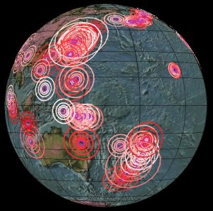
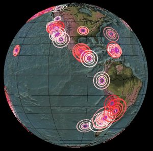
Western side Eastern side
The Pacific “Ring of Fire” during the last 7 days on April 22, 2011
(“fair-use” copies from Earthquake 3D free)